Stay informed with the LNN Daily Newsletter
A deer with a fawn in Crowsnest Pass. (Photo: Nature Conservancy of Canada)

New trail camera project to study wildlife activity in southern Alberta

Sep 19, 2021 | 7:00 AM

CROWSNEST PASS, AB – A project to monitor wildlife movement across Highway 3 in the Crowsnest Pass has been announced.

It’s an initiative between the Nature Conservancy of Canada, the Miistakis Institute and the Alberta Biodiversity Monitoring Institute. The Nature Conservancy says the information gathered from the project will be used to inform future wildlife management strategies, with an aim of reducing the amount of animal and vehicle collisions.

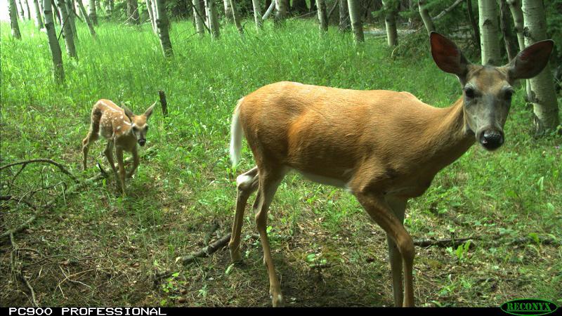
The project is referred to as ‘Linking Landscapes’ and it will utilize wildlife cameras that have been installed throughout the Jim Prentice Wildlife Corridor in the Crowsnest Pass and includes Rock Creek, on the eastern edge of the wildlife corridor.

The cameras are triggered by movement and work 24 hours per day in all lighting conditions.

The Nature Conservancy noted that, “Highway 3 is situated within a low-elevation valley where opportunities for wildlife movement are limited due to roads, development and human activity.”

“Wildlife that attempt to cross the highway risk mortality and injury and pose a significant safety concern for people that live in and travel through the region.”

In addition to the risk to human and animal life, collisions along the highway also include costs for damaged vehicles, hospitalizations and highway cleanup. According to the Alberta Motor Association (AMA), these collisions are one of the leading causes of comprehensive damage claims to vehicles, with the average claim topping $8,000.

17 volunteers in Crowsnest Pass are part of the project and each has been assigned specific cameras to help collect images and identify species.

The camera trap project will use WildTrax, which is an online tool developed by the Alberta Biodiversity Monitoring Institute, for image storage and review.

The Nature Conservancy remarked that monitoring wildlife movements with camera traps will help officials get a better understanding of future conservation and stewardship needs. This can then help in maintaining healthy wildlife populations in the area moving forward.

“By pinpointing the areas of highest use, this data will also generate information leading to recommended strategies in mitigating animal and vehicle collisions on the highway.”

Regional vice-president of the Nature Conservancy of Canada, Tom Lynch-Staunton said, “by determining what species are crossing the highway, where they’re moving, and at what times of year, we can make better recommendations on how to mitigate wildlife and vehicle collisions, which will make the Crowsnest Pass a safer place for people and for animals.”

The Nature Conservancy said almost all of the wildlife species in the foothills and mountain regions of Alberta use this corridor, including ungulates (elk, deer, moose and bighorn sheep) and carnivores (bears, wolves, wolverines and cougars).

Photos from the project can be seen here.