Stay informed with the LNN Daily Newsletter
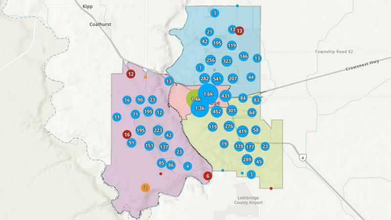
The new crime map from the Lethbridge Police Service shows what types of crimes are occurring in which areas of the city. February 8, 2024. (Photo: LPS)

Lethbridge Police launches crime and traffic maps

Feb 8, 2024 | 11:17 AM

LETHBRIDGE, AB – There is now a new way to see where crimes are being committed in Lethbridge.

The Lethbridge Police Service (LPS) has launched Open Data, an interactive platform that provides public access to policing activity data, including crime statistics, traffic infractions and other related trends in the city.

The crime and traffic maps show select incidents that have a known location. The maps are refreshed every 24 hours and searches can be customized.

Further details on how the maps were are provided by the LPS below:

“Maps are displayed showing the four patrol beats within the city – North, South, Downtown and West. In areas with multiple offences in close proximity, the data is displayed as a cluster, indicating the most predominant crime type. By clicking the ‘browse’ option a summary list will show each crime and users can further click on each incident to view the occurrence date, reported time, file number, crime category and Uniform Crime Reporting code. There’s also a submit tip function to provide anonymous tips to Crime Stoppers,” reads a media release from the LPS.

Datasets can be exported to formats such as CSV, Shapefile and GeoJSON.

The police service said they could add additional maps in the future.

The crime and traffic maps can be accessed on the Lethbridge Police website.

READ MORE: Lethbridge News Now

If you have a news tip, question or concern, please email Lethbridge.newsroom@Pattisonmedia.com.

For local news delivered daily to your email inbox, subscribe for free to the Lethbridge News Now newsletter here. You can also download the Lethbridge News Now mobile app in the Google Play and the Apple App Stores.