Stay informed with the LNN Daily Newsletter
18 Street in Lethbridge, where the City of Lethbridge is potentially looking to build a new transportation corridor. (Image Credit: City of Lethbridge)

Input needed for future north-south corridor in Lethbridge

Jan 16, 2026 | 10:37 AM

The City of Lethbridge wants to hear from you on how it can better connect people between the north and south sides.

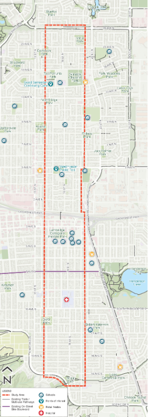
They are beginning a functional planning and design study for an active transportation link between Winston Churchill High School and the Sugar Bowl, or from 26 Avenue North to Scenic Drive South between 16 Street North/South and 20 Street North/South.

Officials with the city say this corridor is an important connector, and it plays a major role in how residents connect to:

  • The Sugar Bowl park at Scenic Drive
  • Chinook Regional Hospital
  • Several schools (Winston Churchill, Galbraith Elementary, Westminster Elementary and Lethbridge Collegiate Institute (LCI))
  • Nearby parks, shopping areas and residential neighbourhoods

The 2017 Cycling Master Plan identifies 18 Street as a future “bike boulevard,” and the City plans to look into ways to make the street safer and more comfortable for people of all ages and abilities.

The study will explore whether 18 Street is the best spot for a north-south bike route. The City assures that sidewalks will stay, vehicle lanes will not change, and any parking adjustments will be small.

Municipal officials are planning four rounds of public engagement.

The first is the Community Conversation on Thursday, Jan. 29, from 3:00-7:00 p.m., at the VisitLethbridge.com Arena. This is an opportunity to learn more about the project, and ask questions to the staff members involved in the project.

An online survey is also available.

The City of Lethbridge hopes to have a finalized design in the third quarter of 2026. There will be opportunities for the public to comment on the concept design and functional design before then.

Map showing the proposed area for the north-south transportation connector.
Map showing the proposed area for the north-south transportation connector. (Image Credit: City of Lethbridge)