Stay informed with the LNN Daily Newsletter
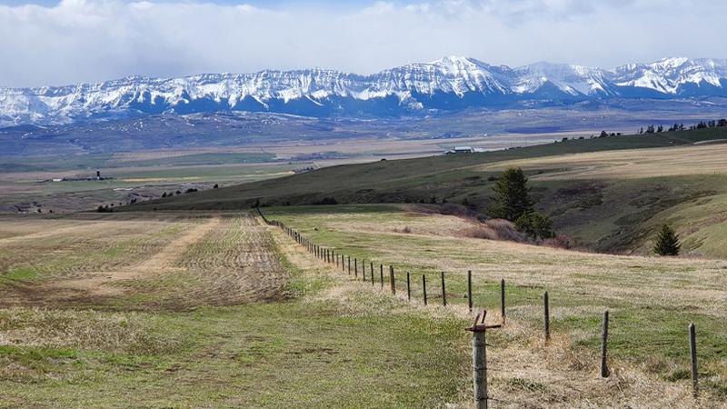
(Photo: Dr. Chris Hopkinson, via the University of Lethbridge)

U of L team takes on project measuring provincial snowpack

May 28, 2024 | 2:52 PM

LETHBRIDGE, AB – A team of researchers from the University of Lethbridge (U of L) was recently enlisted by the provincial government to help with accurately measuring the snowpack in southern Alberta.

Researchers were also asked to take a look at the variations from one watershed to another.

Officials say these measurements are more important than ever with drought being top of mind for many Albertans.

“Given the potential for drought, following a couple of years of already dry conditions and low snowpack, the Government of Alberta approached us at the beginning of January to see if we could help them with the snow monitoring,” says Dr. Chris Hopkinson.

Hopkinson is a professor in the University of Lethbridge’s Department of Geography and Environment and director of the new TECTERRA-funded Institute for Geospatial Inquiry, Instruction and Innovation (i4Geo).

For seven months of the year, scientists with Alberta Environment and Protected Areas (AEPA) venture into the mountains in the backcountry to measure snow depth and density. Officials say this information is critical to managing water and reservoir levels in Alberta.

The U of L notes researchers utilize data obtained from airborne LiDAR (Light Detection and Ranging), a remote sensing system that can map snow depth, for more accuracy.

“Effectively responding to drought, both this year and in the future, requires a better understanding of snowpack conditions in the mountains and the amount of water we can expect during the spring melt to refill our reservoirs and recharge our rivers,” says Dr. Brandi Newton, a hydroclimatologist with AEPA.

“Partnering with the University of Lethbridge on the use of LiDAR in our snow survey program allows us to collect detailed snowpack data over a much wider area and will ultimately help Alberta make the most out of every drop.”

For southern Alberta’s Bow and Oldman watersheds, Hopkinson and his team started planning two airborne missions, one in March and another in April.

The mission in March saw the use of a state-of-the-art Galaxy LiDAR system and operator provided by Teledyne Optech, with Calgary’s Aries Aviation providing the aircraft. In April, researchers used the U of L’s Titan Multispectral LiDAR system, with some operational support from Airborne Imaging out of Calgary. The scans sampled the Rockies from as far south as the United States border and north to Saskatchewan Crossing.

“The data is confirming that the snowpack in the mountains is not very abundant,” says Hopkinson, adding, “But it’s important to bear in mind that we don’t really have anything to compare it to because we’ve never done this before.”

“All we can do is take our estimates of snowpack water equivalents in the mountains and relate it to similar data structures such as precipitation gauges, snow pillows, field data or runoff records.”

Officials say that while the LiDAR results are comparable to traditional measurements, it can also provide more spatially precise information.

“It’s telling us, for example, that the Oldman is showing a lot less snow water in the mountains than the Bow,” says Hopkinson.

“But we’d probably expect that anyway just because the Bow is higher in elevation, slightly farther north and has wider mountains. But now we’re able to quantify these things in a way we previously couldn’t.”

Members of Hopkinson’s team include Dr. Celeste Barnes, master’s student Jessica Van Gaalen, and PhD candidate Italo Rodrigues. Maxim Okhrimenko, a PhD student and LiDAR lab manager, helped plan the surveys and flying while research associate Farnoosh Aslami helped by working up data layers as needed. Dr. James Craig of the University of Waterloo and Dr. Ryan MacDonald, CEO of MacHydro Consultants, also worked on the project.

“The idea is that we’ll use [this] data to input into a hydrological modelling scheme to do the forecasting,” says Hopkinson.

“It’s innovative because you don’t normally have a spatially continuous map of snowpack that you can then put into a hydrological model. Hopefully, in the next month or two, we’ll get some scenarios from [this] data that will parallel or supplement the kind of forecasting work the province is doing.”

The U of L says that going forward, having more precise snowpack measurements will help to guide water management policies and practices.

READ MORE: Lethbridge News Now.

If you have a news tip, question or concern, please email Lethbridge.newsroom@Pattisonmedia.com.